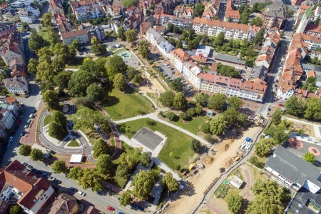
The new water playground at Norikusbucht Cove on the southern banks of Wöhrder See Lake in Nuremberg is the most important ‘attraction’ in this section of the area of the park besides the new swimming bay and the movement parcours and was created when this 1970s park was renovated and re-designed.
The re-design took place as a result of the extensive hydraulic engineering measures that were necessary as part of the ‘Wöhrder See Water World’ project, carried out by the water authority of Nuremberg. A new breakwater dam will now separate the Norikus Cove from Wöhrder See Lake and lead to optimisation of the flow behaviour and thus a reduction in silting. This will substantially improve the water quality of the Lake, which was created approximately 50 years ago by the impoundment of the Pegnitz River. In Norikus Cove approximately 10,000 m² of uncultivated land was also reclaimed besides the dam area and further sections of the park were impeded by the construction measures.
This measure made re-planning of the landscape of the entire section of the bank unavoidable, an area where there had been a water playground, abandoned many years before. The structure of the old water feature, with approximately 2,500m² of asphalted base and in-situ concrete edges, was one of the most defining elements in the original park with the areas of the old water playground traversing the entire eastern park. Some parts had been backfilled in the meantime and were either covered in grass or had been converted into a normal playground. The renovation and return to use was a wish that the citizens had been expressing to the City of Nuremberg for many years and it could now be realised as part of the redesign of the park.
Even though the existing structures appeared to still be in good condition it was no longer possible to simply renovate them and return them to use: the surfaces had been constructed without any gradient and therefore created bad quality standing water when in use. However, the most important legacy of the old water playground was the deep well that allowed the extraction of large quantities of fresh water (XXXm3/h withdrawal quantity) for use on the water playground. Water analyses that had been carried out in the meantime showed very good water quality, providing the most important prerequisite for the new water playground.
At the start of planning there was both a moderated public participation event to set the planning objectives for the entire park and a separate child participation event for the water playground in the form of a small workshop where the children could allow their creativity free reign with drawings and models to develop a foundation of ideas for the planned water playground.
The new water playground
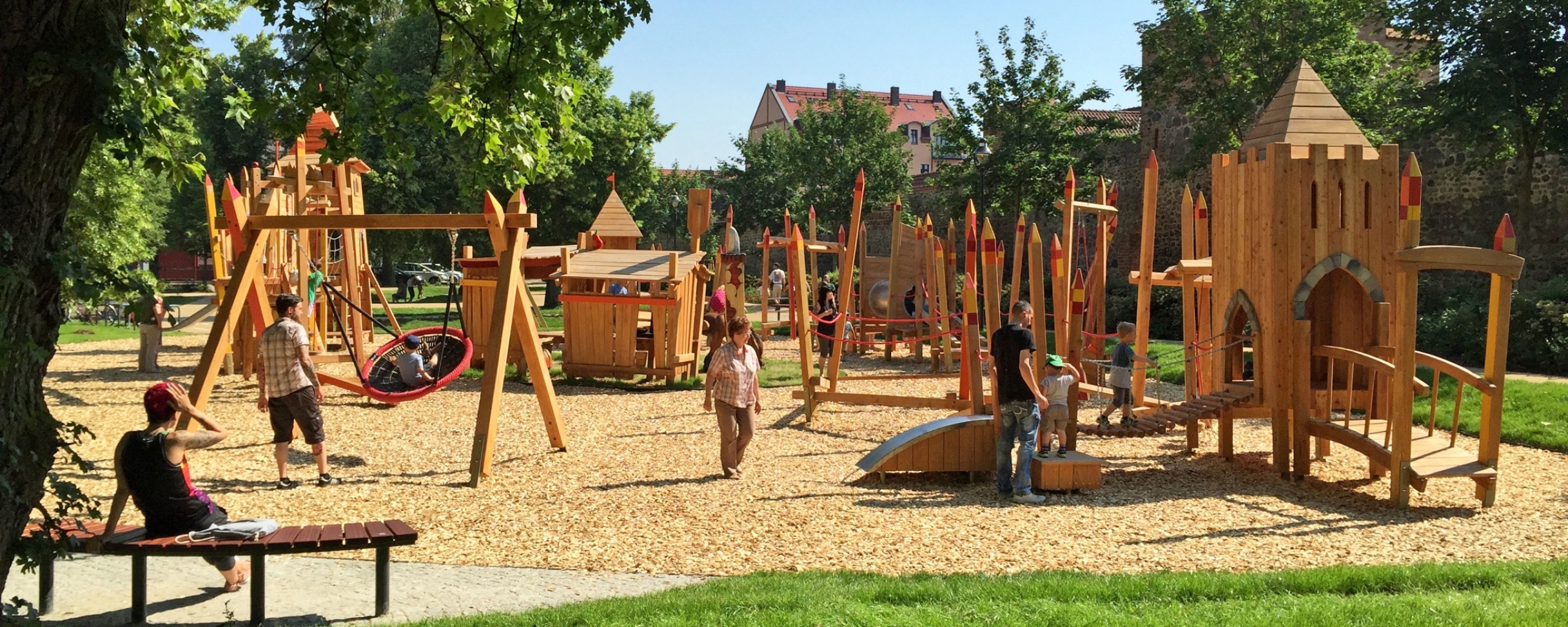
Today, the new water playground stretches from the main path to the shore path within the new system of paths in the north east of the park. Four entrances provide access to the playground from both paths but it remains shielded from the busy routes in the park, both spatially and with regard to traffic flow. A barely visible enclosure is hidden in areas of planted grasses. The generously sized entrances are marked with gates and metal fences that are themed using shape and colour. Large areas of the water playground are located on the former channels and tanks of the old water playground, the polygon style of which is continued and expanded. This achieves attractive integration into the existing tree population. The playground is surrounded by seating and screened by a frame of grass vegetation behind that.
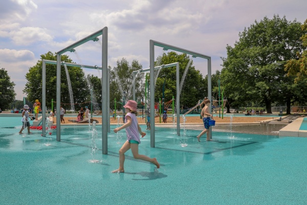
The spine of the water playground is formed by a watercourse fed by two differently staged sources and leading through the entire playground towards Wöhrder See Lake. The strips of water, which are designed in a very structural and designed way where they begin at the sources, allow the water to flow along many play and guiding elements until the course continues to become an increasingly natural and extensive stream that finally ends in the Wöhrder See Lake. It is very interesting to follow the path of the water from the source to the mouth, not just for children. At the heart of the playground the watercourse encloses a large area of sand, into which water is fed from the channel system in different places. This produces large areas of water-sand-mud. There is also a rope net structure as a climbing frame at the centre of the sand area so that the playground is an attractive feature all year round.
The two source elements are very different to one another: while the first source forms the starting point of the channel wall in the south as a simple overflowing spring, the second source element in the south east shapes the large ‘water square’. Here, the water bubbles spectacularly from a high steel structure (‘source house’) via showers from above and also shoots from nozzles in the ground as fountains. In order to maintain the high quantities of water that are necessary here, the water from the deep well is collected in a cistern for several minutes before being fed to the system, also for a few minutes, using automatic time switching. This creates wonderful moments of surprise (not only) for children of all age groups and provides a flow for the activity areas on the playground. The water for the second source element is fed directly into the channel system on the sand via the square area.
The channel wall collects the water from the source points and guides it along the sand area towards Wöhrder See Lake. At the starting point in the south the channel rises visibly out of the ground to allow play while standing. Wooden water and mud tables have been placed on the sand side, where water can be fed out of the channel. There are also barrages and channelling opportunities in the sand downstream towards the water square at the second source. Visitors can twist streams in and out of one another as they please here and fashion reservoir lakes. Once it arrives at the square at the site level the channel unites with the water from the second source and flows to the west in a section of the channel with further barrages, outlet points and a water wheel that slowly descends into a section of the channel that is below the site level. Further downstream boulders and other ground formations have been added to create flow patterns or just for balance. Before it joins the natural stream formation, the water is guided through a flow model of Wöhrder See Lake where the original course of the Pegnitz River and today’s Wöhrder See Lake are incorporated at different heights. The water then finally runs into Wöhrder See Lake in a small, natural stream at a flat point.
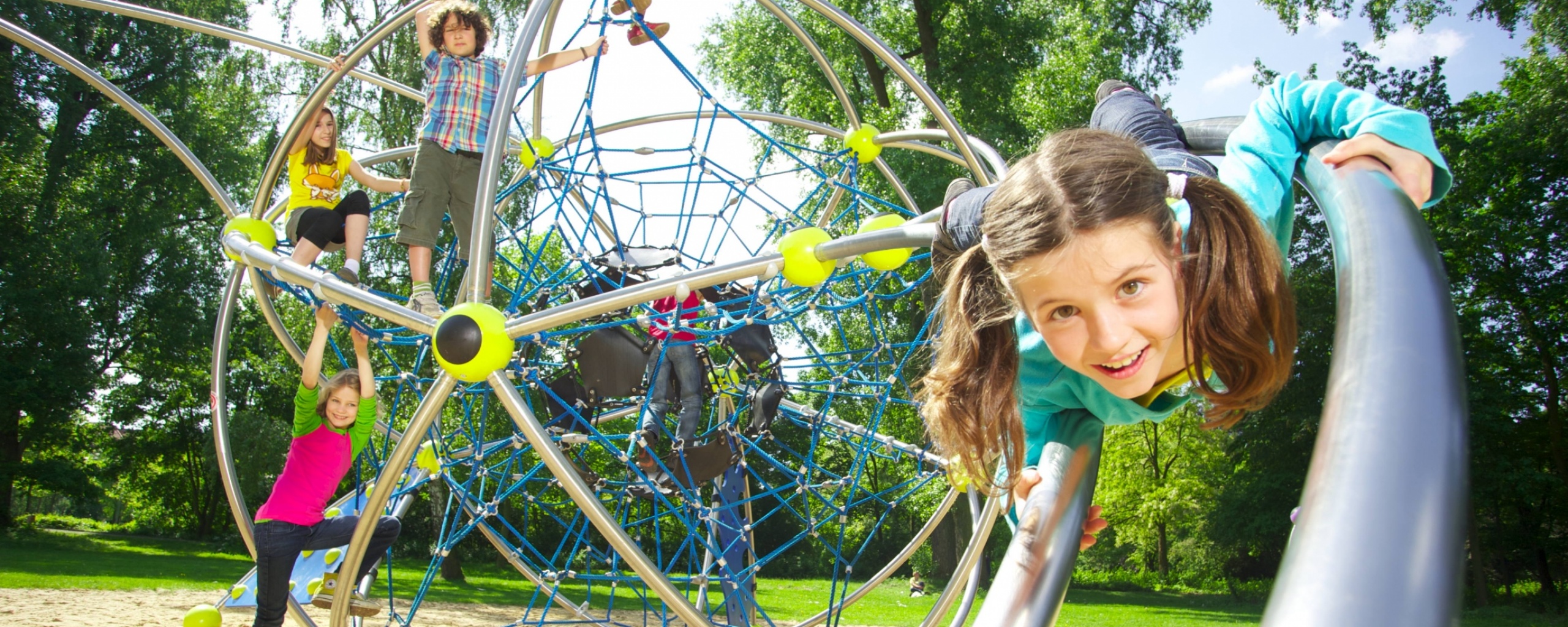
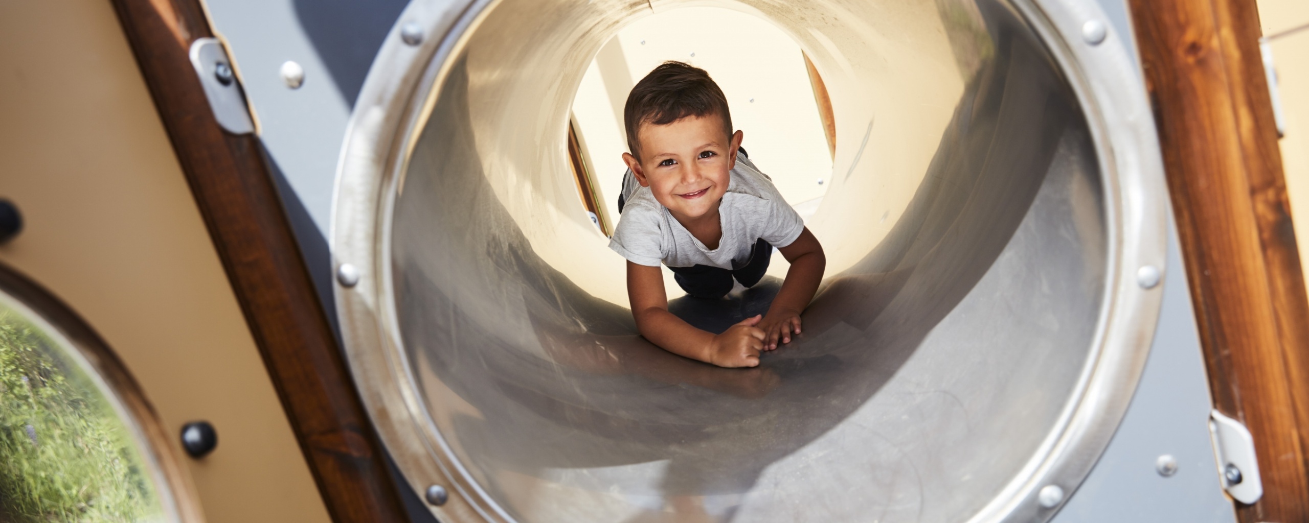
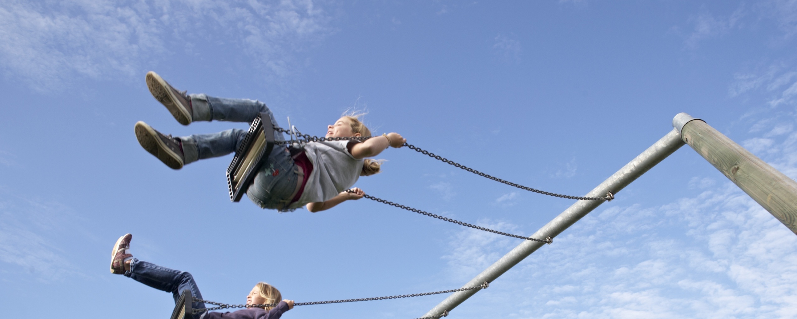
Part of the sandy area is taken up by a system of rope nets that has been developed as a climbing parcours site. It has its own character with posts that resemble water plants. The highest point of the system is a viewpoint that allows visitors to look across the entire play area. A small house, a slide and swinging, climbing and balancing elements enable children of different ages to play together, even in weather conditions that are not suitable for water play.
One particularly important aspect in the planning was achieving the correct balance of water flow: at times when only a few children are playing because of the weather or the time of day the water runs in the channels in a controlled manner and forms a water element where visitors can spend quality time. Locks and flap gates must be positioned in such a way that there are no places where the water runs out of the channel and leads to excessive wetting of the sand areas before it has been played with. At the same time an even bottom slope must be ensured along the entire course of the water without impeding play or safety.
About the planning area
The planning area is located in the east of the City of Nuremberg on the southern banks of Wöhrder See Lake. It encompasses the public park neighbouring the Norikus Tower. The east-west extent reaches from the newly designed partial area at Kressengartenweg in the west to the open-air swimming pool in the east. The northern boundary is marked by the new line of the shore on the lower Wöhrder See Lake with the breakwater. To the south Norikus Tower and its outdoor areas form the boundary together with a slope edge. The section that is thus enclosed has an area of approx. 72,300 m². Without the water areas the area is approx. 55,000 m². In addition to the existing facilities the park will also include more structures such as a shoreline meadow and a movement parcours in order to adapt it to growing user requirements. The plans have space for many outdoor activities as well as walking, cycling, play across multiple areas and experience with nature, thus achieving park use by different generations.
Photo: Andreas Hofmann
Project information:
Overall project:
Wöhrder See – South bank and Norikusbucht Cove, Nuremberg
2015 to 2018 | 55,000m² | 2,900,000 €
Client: The City of Nuremberg - SÖR
Performance: LP 1-9 HOAI §39 Outdoor installations
Partial project water play area at Norikusbucht Cove on Wöhrder See Lake, Nuremberg
2015 to 2018 | 4,000m² | 680,000 €
Client: The City of Nuremberg - SÖR
Performance: LP 1-9 HOAI §39 Outdoor installations
Client: The City of Nuremberg
Service operations by Öffentlicher Raum Nürnberg
Own operations by the City of Nuremberg
SÖR/1-G Planning and green construction
Project Manager: Bernd Nitschke
Landscape architecture / Group Manager for construction
Planning:
Hackl Hofmann Landschaftsarchitekten GmbH
Project Managers Stephanie Hackl, Andreas Hofmann
Staff: Daniel Enders, Sabrina Jodoin, Anja Vogel
(www.hackl-hofmann.de)
Project participants:
Nuremberg Water Authority
Presentation for citizens’ participation: Prof. Gerd Aufmkolk, Nuremberg
Water technology: Z&Z Wassertechnik GmbH
Play apparatus: Richter, Corocord
Landscape architecture: Gustav Biedenbacher Garten- und Landschaftsbau GmbH
Making people aware of the value and benefits of open spaces: How to make landscape architecture more sustainable? If you want to build sustainably, you can follow guidelines and be benchmarked using assessment systems and certificates.
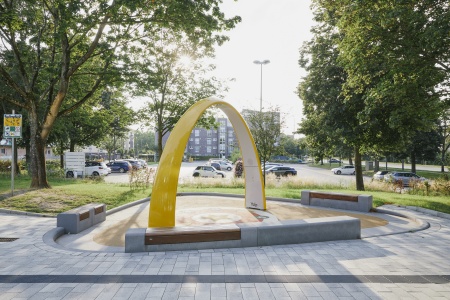
Konrad-Adenauer-Platz has been extensively redesigned. The aim was to improve the quality of stay through playground equipment, water, greenery and street furniture.
Healthy, equal, resilient and thus liveable municipalities are characterised by the fact that health concerns such as rest, recreation, well-being, physical activity, stress management and relaxation have a ...
For many years, the city of Hildesheim has received subsidies from the federal government and the state through the urban development funding programme, thus contributing significantly to the implementation of ...
In der vom Bundesinstitut für Bau-, Stadt- und Raumforschung (BBSR) durchgeführten Modellvorhabenforschung des experimentellen Wohnungs- und Städtebaus (ExWoSt) konnten viele...